
Land Acquisition Fund: urgent action prevents mining in…
05 April, 2024
Land Acquisition Fund: urgent action prevents mining in…
05 April, 2024

Call for letters of inquiry for small grants…
01 April, 2024
Friday 25 october 2019
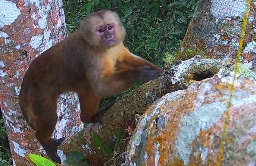
Header photo: Ecuadorian White-Fronted Capuchin © Third Millennium Alliance
Large-scale deforestation in the northern Manabí province of Ecuador has caused severe fragmentation of what was once a vast forest area. The isolated remnants of forest offer habitats of insufficient size for species to survive. This is driving species to the brink of extinction. The endemic Ecuadorian White-Fronted Capuchin (Cebus aequatorialis) is listed as Critically Endangered on the IUCN Red List of Threatened Species.
A wildlife migration corridor seemed like a good idea to reconnect the isolated patches of forest in order to increase the habitat of the White-Fronted Ecuadorian Capuchin and other species. Yet, partner organization TMA faced a lack of data (e.g. related to forest quality and remaining biodiversity) to determine the most viable interventions to save this and other species.
A wildlife migration corridor between the isolated patches of forest was needed to increase the habitat for the Critically Endangered White-Fronted Ecuadorian Capuchin. To identify the best location for this connective corridor, IUCN NL supported TMA in the use of satellite imagery to create a detailed land cover map.
This land cover map, combined with the local expertise from TMA and with dynamic parameters, such as ecological pressure factors, conservation priorities, deforestation risk and projected climate change, formed the basis for a predictive model to calculate the most suitable linear wildlife migration corridor in the Manabí province.
The study identified an area with the potential to create a 100-km long wildlife migration corridor. This corridor would reconnect the three principal reserves (mention) in the northern Manabí province.
The calculated corridor and land cover maps are now being used by TMA to strategize and plan their future conservation activities, including land purchase and reforestation activities aimed at protecting habitat and building connectivity for a diverse set of threatened species that live in the landscape, including the White-Fronted Ecuadorian Capuchin.
The insights gained from this study will also be used to inspire other local actors to improve their conservation strategies through GIS analysis.


05 April, 2024
The Alliance for the Tompotika Conservation has secured important habitat of the maleo on the Indonesian island of Sulawesi through…

01 April, 2024
The Critical Ecosystem Partnership Fund (CEPF) and its regional implementation team (RIT) for the hotspot, are accepting letters of inquiry (LOIs) from…