Land Acquisition Fund: urgent action prevents mining in…
05 April, 2024
Land Acquisition Fund: urgent action prevents mining in…
05 April, 2024
Call for letters of inquiry for small grants…
01 April, 2024
Monday 08 february 2021
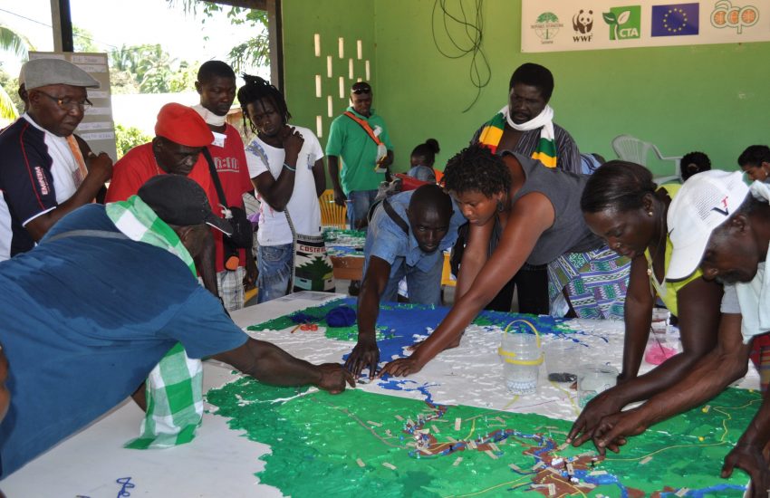
Header photo : Participatory mapping in Suriname © Tropenbos Suriname
The Saamakans are an afro-descendant community living in the interior forests of Suriname, along the country’s eponymous river, for more than 300 years. These communities practice traditional agriculture, hunting, fishing and harvesting timber and non-timber forest products, managing the forest sustainably through customary law.
With the development of roads and dams in the region, the Saamakans face growing challenges to conserve their land and resources, as well as to maintain a sustainable way of life. Poachers, loggers and miners follow road developments, degrading their forest, but even many of the Saamakans have turned to these activities in search of improved economic opportunities to afford new lifestyles as well as education and health services.
Moreover, young people emigrate to the cities or gold mining fields, abandoning traditional livelihood activities, interrupting local community life and the transfer of traditional knowledge from their elders.
When seen from above through remote sensing, the upper Saamaka river region appears as a mosaic of intact primary forest and a fringe of secondary forest along the river as a result of shifting cultivation. While this level of data is useful to understand the effects of land use development on forest, it leaves important knowledge gaps on the social, cultural and environmental issues present within the Saamaka territory.
It is therefore essential that land use decision makers and conservation practitioners gain a better understanding of the main issues that Saamaka communities face on the ground. Moreover, it is important that the knowledge generated can be accessible to local communities while effectively enabling locally owned solutions to Saamaka issues and challenges.
This is how between 2013 and 2016, IUCN NL partners Tropenbos Suriname, the Association of Saamaka Authorities (VSG) and WWF Guianas engaged with the Saamaka communities to co-produce local spatial knowledge to understand the landscape from an internal, community perspective.
Through participatory 3D mapping and focus groups workshops, community members mapped ecosystem services they derive from the forest for their food, materials, and fuel, as well as important cultural and other community sites. Through interview processes, they also identified under how much pressure different key local sites where and how resources were distributed among community members.
This work revealed an extensive use of the territory by Saamaka communities that goes far beyond the river margins and that includes many de facto forest reserves for future use. The work also showed how over the last years communities have changed their dependence on some forest products to rely on more western goods such as oils for cooking and cosmetic use (instead of native Amazon palm oils with long history of traditional use), which they more easily purchase now in markets. The participatory mapping process also revealed some equity concerns in the distribution of important livelihood resources within communities.
More importantly, the maps produced made spatially explicit the deep knowledge that Saamaka people have on their territory. This type of spatially explicit knowledge can be used by communities to negotiate a better position when confronted with external developments, such as logging and gold mining.
While maps and their knowledge can be powerful and useful tools, many community members have difficulties using them to advocate for their interests, partly due to the complexity of the language that usually such outputs and outcomes have for local community members. To bring these maps and other project’s knowledge products closer to the communities, in 2020 IUCN NL, Tropenbos, WWF-NL and Utrecht University supported the production and distribution of the booklet Taki U Saamaka Sëmbë: a di fasi fa wooko o seeka a di matu (Saamaka Voices on Land-use Decisions).
This highly illustrated booklet brings back to the Saamaka community, in a simple accessible language, the knowledge they shared for the 3D mapping project.
The booklet presents ways in which local communities can use the generated knowledge and maps of community use areas, and addresses how communities may deal with potential challenges in using this information.
The publication emphasizes the importance of local communities being recognized as the owners of this knowledge. External organisations can also play a role in supporting them to use the knowledge in policy making. In recognition of this, a local Saamaka traditional leader says: ‘It is often the case that we, communities, are only providers of information while the knowledge products and the opportunities to apply it stay with outsiders.’
The Saamaka version of the publication was distributed to more than 200 hundred community leaders in the Saamaka territory.
We hope this publication can become a tool for the communities in discussing land use issues and thus change the top down way communities are usually engaged in research. Adoption and full acceptance of this information by governments and other organisations is also urgent and useful, especially now that Indigenous and Tribal Rights are in the process of recognition in Suriname.
Together with our partners, over the coming years we hope to continue working with the Saamaka to empower these communities so they can fully exercise their rights over their territory and manage it sustainably, according to their own traditions and customs.
The booklet is also available in Dutch and Saamakan, the local language:
05 April, 2024
The Alliance for the Tompotika Conservation has secured important habitat of the maleo on the Indonesian island of Sulawesi through…
01 April, 2024
The Critical Ecosystem Partnership Fund (CEPF) and its regional implementation team (RIT) for the hotspot, are accepting letters of inquiry (LOIs) from…