Social forestry in Indonesia: forest protection and sustainable livelihoods amid flash floods

Critical minerals and the western chimpanzee: how bauxite…
24 March, 2026
Tuesday 17 february 2026
Latest news has painted a devastating picture of the situation in Sumatra, Indonesia. Torrential rains coming with cyclonic storm Senyar in late November 2025 triggered flash floods that tore through villages, taking the lives of many, destroying infrastructure, homes and crops, and leaving landscapes in ruins.[1]Source: Flash Floods in Sumatra 2025: When Nature’s Fury Met Human Vulnerability – Malota Studio Sumatra Flash Floods 2025: Data, Impact, and Lessons Learned While climate change is undeniably pushing cyclones and rainfall patterns to new extremes, the severity of such disasters is multiplied in places where forest cover has diminished, mostly due to expanding extractive frontiers.[2]Source: Deforestation made the cyclone more deadly: NGOs from Northern Sumatra – Fern Mining, palm oil plantations, and logging strip forest landscapes and hillsides of their water-retaining capacity and expose communities to escalating risk.[3]Source: How Sumatra’s lost trees turned extreme rain into catastrophe
Header photo: © KKI WARSI
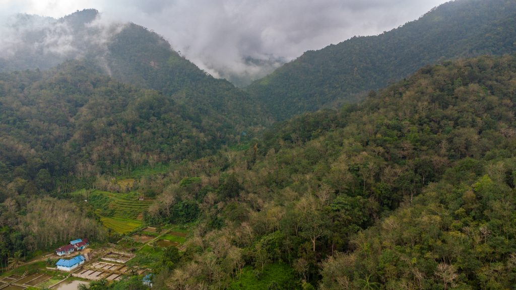
Against this backdrop, more than a decade of work with our partner organisation KKI Warsi, who work upland communities in West Sumatra, shows that locally-led forest governance is a crucial steppingstone toward protecting water sources, strengthening sustainable livelihoods and reducing disaster risks. At the same time, it makes clear that forest protection must go hand-in-hand with halting destructive land conversion and addressing the wider climate crisis that magnifies the impacts of floods.
Connecting forests, water, and people
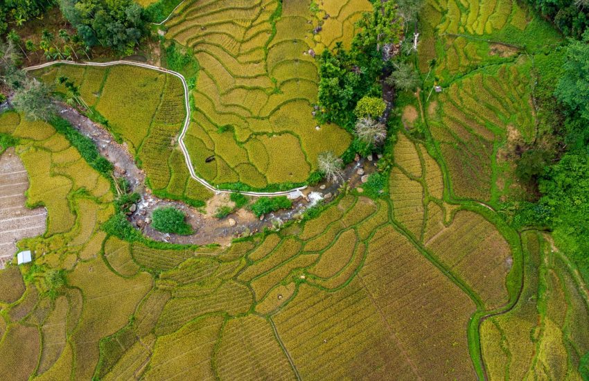
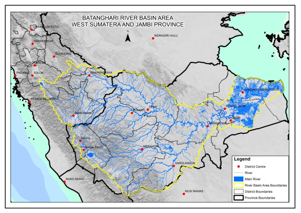
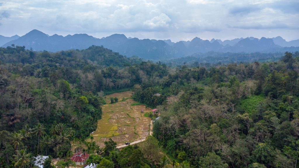
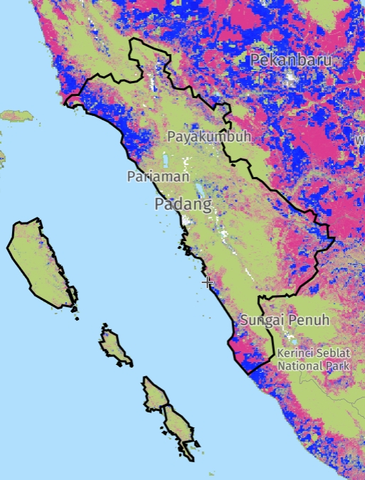
The Batanghari River, which springs from the highlands of the Minangkabau region, is the longest river on Sumatra. It stretches approximately 800 km and encompasses a catchment area of 4.9 million hectares, thereby connecting communities, ecosystems, and livelihoods along its course. More generally, the Batanghari watershed is the second largest river basin in Indonesia and has been designated as one of the 22 critically degraded watersheds in the country. The Batanghari River originates in Solok Selatan (West Sumatra) in the landscape of Mudiak Baduo. It is a vast forested watershed: its trees and soils absorb rainfall, allow slow water infiltration into the ground, stabilise slopes, and regulate seasonal variations.
When these upstream forests – as well as forests along the course of the river – are lost due to plantation expansion, mining, logging, or land conversion, essential natural buffers collapse. This dramatically increases the risk of landslides and flash floods. In other words, what happens in the highlands and upstream area of Mudiak Baduo does not stay there. It affects water flows, agriculture, ecosystems, lives and livelihoods, and the wellbeing of communities in the entire Batanghari watershed.[4]Source: https://www.earthsight.org.uk/news/sumatra-floods
Catastrophic flash floods on Sumatra
In November 2025, Sumatra has been hit by catastrophic flash floods caused by cyclonic storm Senyar that ripped through entire villages, destroying homes and infrastructure (over 152,000 houses were destroyed and around 1,200 public facilities damaged), taking the lives of many (1,177 deaths were recorded) and leaving vast areas scarred. The heavy rainfall brought by cyclone Seynar – a new phenomenon in these geographical latitudes – soon turned into torrents as rivers overflowed and hillsides gave way. Shifting climate patterns, combined with increasingly extreme weather, clearly played a role, and will do so even more severely in the future.[5]Source: Areas Most at Risk of Flooding | World Resources Institute It becomes clear, however, that the impact of the disaster worsened by widespread forest loss, as for instance shown in recent research that reveals the links between deforestation, illegal logging, and the disastrous floods. In that sense, the floods revealed the collapse of water-regulating functions. The recently published Asian Water Development Outlook 2025[6]Source: Asian Water Development Outlook 2025: The Index of Water Security for Asia and the Pacific confirms that “(d)isaster risk is not caused by extreme events alone. It is shaped by development choices, inequality, and weak governance. These deeper drivers are often overlooked.”
Land conversion drives floods
In the case of Sumatra, the Directorate General of Watershed Management and Forest Rehabilitation of the Ministry of Forestry, revealed that the massive land conversion in West Sumatra, Aceh, and North Sumatra was the culprit of the flash floods.[7]Source: https://lestari.kompas.com/read/2025/12/10/135827586/banjir-di-sumatera-kemenhut-beberkan-masifnya-alih-fungsi-lahan Forestry expert Bambang Hero Saharjo of IPB University in West Java noted that numerous cases since the 2000s have shown concessions for large-scale monoculture plantations had been built in Sumatran forests with dense tree cover.[8]Source: Rising forest loss puts Kalimantan at higher disaster risk – Society – The Jakarta Post ‘The development of industrial forest plantations often ignores existing regulations that require the industrial forest to be built in nonproductive areas,’ Bambang said. ‘In practice, many of them were developed in protected and productive forest areas.’ To put this statement in perspective, around 1.4 million hectares of forest across Aceh, North Sumatra and West Sumatra were cleared between 2016 and 2026 to make room for plantations and mining, according to WALHI (the Indonesian Forum for the Environment). The hardest-hit areas during last month’s disaster were degraded watersheds.[9]Source: https://www.thejakartapost.com/indonesia/2025/12/13/women-bear-brunt-of-sumatra-floods-as-basic-needs-remain-unmet.html.
In this fragile environment, protecting remaining forests and restoration of degraded forests is a matter of human survival. That is why strengthening community-led forest governance now stands at the heart of any sincere effort to maintain water retaining functions, safeguard ecosystems, and protect rural lives and livelihoods.
Expanding extractive frontiers and deepened inequalities
In Indonesia, forests are classified as state land, enabling the issuance of logging, mining, and industrial plantation permits with minimal consideration for local communities or environmental protection.[10]Source: Social forestry supports communities and biodiversity in Popayato, Indonesia | IUCN NL Over the past two decades, data from WALHI reveals that hundreds of thousands of hectares in North Sumatra, West Sumatra, and Aceh have been deforested due to extractive licenses granted to 631 companies.[11]Source: Transisi Energi Palsu_EN Version.cdr According to the Mining Advocacy Network, this trend reflects a systemic contradiction: while illegal mining is often blamed for environmental damage, thousands of legal permits for mining, hydropower, geothermal projects, palm oil, and forestry concessions dominate upstream watershed areas – critical ecosystems that sustain communities in Aceh, North Sumatra, and West Sumatra. Accelerated downstream mining projects, expansion of large-scale energy initiatives, and consolidation of resource oligarchies further entrench an extractive economic model, exacerbating deforestation and watershed degradation across these regions.[12]Source: https://www.abc.net.au/news/2025-12-04/why-is-indonesia-the-most-severly-affected-by-cyclone-senyar/106095614
The numbers speak for themselves: in the past two decades, Aceh and West Sumatra lost more than 320,000 hectares of primary forest, while North Sumatra lost more than 390,000 hectares.[13]Source: https://www.globalforestwatch.org/dashboards/country/IDN/30/?category=undefined
This extractive imperative is worrying, even more so in light of the recent devastating floods. Communities in Sumatra have already experienced more frequent floods and landslides since the expansion of palm oil, and pulp and paper plantations. Losing what remains of the forest would only intensify the impacts of such disasters. Deforestation, watershed damage, and exposure to flash floods go together.[14]Source: https://www.walhi.or.id/walhi-desak-kementerian-kehutanan-tindak-aktivitas-ilegal-dan-cabut-perizinan-berusaha-perusahaan-penyebab-banjir-sumatera
Meanwhile, those who suffer the worst impacts gain nothing from extractive rentiers: stark power imbalances and elite capture enable large companies to profit from exploitative models while local people shoulder the risks and damages. This underscores the urgent need to prioritise community-led stewardship.
Social forestry halts forest loss and prevents floods
Social forestry is a powerful approach to protect forests while strengthening communities, acting as both a preventative tool against flash floods and a source of sustainable livelihoods. The idea of social forestry is that local communities are leading forest management. This makes social forestry a viable alternative to protected areas, which have historically excluded communities’ forests access in the Indonesian context.
Under the Green Livelihoods Alliance (GLA) and other current and past programs, IUCN NL and its Sumatra-based partner KKI WARSI have advanced this approach, recognising the forest’s essential role in regulating water flows and sustaining communities. Yet, obtaining a social forestry permit – valid for 35 years – is notoriously complex. The process is highly technical, bureaucratic, and time-consuming, and requires specific technical expertise.
This is where WARSI’s long-term engagement has made a difference. By guiding communities through the permitting maze and advocating for policy reform, WARSI has helped accelerate approvals and simplify procedures. As a result, the area of sustainably managed forests in West Sumatra grew from 58,865 hectares in 2022 to 60,442 hectares in 2023. WARSI also pushed for provincial regulations to speed up licensing and initiated district-level Social Forestry Acceleration Working Groups, ensuring that social forestry is integrated into broader landscape planning and supported by local governments.
Supporting livelihoods
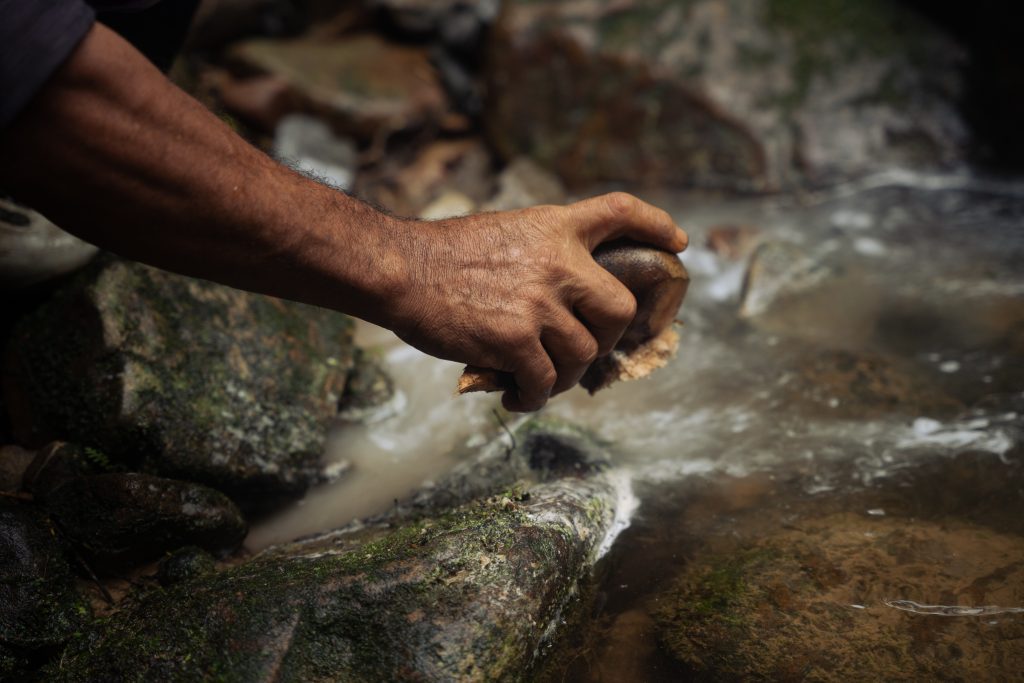
The social forestry approach does not only protect forest ecosystems but also supports livelihoods. Many villagers in Mudiak Baduo and Sumpur Kudus depend on irrigated rice fields that require a reliable water supply, which in turn depends on healthy forests. Protecting the forest therefore enables communities to secure water, strengthen resilience against flash floods, and sustain livelihoods that reduce underlying poverty. The other way around, long-term forest protection goals can only succeed if basic needs are covered and livelihoods secured.[15]Source: Report: Locally-led sustainable development | IUCN NL
IUCN NL’s role in Indonesia
Through the GLA programmes from 2016 to 2025, IUCN NL has championed the power of working in alliances—both at the country level and internationally. Collaboration within alliances creates opportunities for learning and innovation. As WARSI highlighted, diverse approaches from different civil society organisations (CSOs) complement each other, leading to stronger strategies. In advocacy, a single organisation may face limitations, but as an alliance, impact is amplified.
The alliance connected Indonesian organisations not only with each other but also with Dutch civil society and CSOs from other countries. This fosters a global civil society network, enabling cross-country exchanges and strengthening collective action for policy change.[16]Source: 15 years of Strategic Partnerships: Indonesian CSOs reflect | IUCN NL
Recognising that sustainable forest management, transition towards water justice, and improved livelihoods require long-term engagement, IUCN NL has supported WARSI in stacking consecutive projects to maintain momentum and expand reach. A series of projects that first focused on on the West Sumatra landscapes of Mudiak Baduo and Sumpur Kudus, later expanded and replicated the approach in in other parts of West Sumatra and in Jambi and Bengkulu provinces.
Taken together, these efforts contribute to the broader goal of sustainably and inclusively governing tropical forests and forest landscapes, helping to mitigate and adapt to climate change, uphold human rights, and safeguard local livelihoods.
Lessons learned from more than a decade of promoting social forestry on Sumatra
- In West Sumatra, forests, water protection, and livelihoods are closely intertwined. Social forestry has proven to be an effective approach for safeguarding forest ecosystems, reducing the risk of flash floods, and sustaining the communities whose lives depend on stable water flows. CSOs such as WARSI play an indispensable role in driving this forward.
- As climate extremes intensify, halting the expansion of extractive frontiers is more urgent than ever. The conversion of land for palm oil plantations, mining, and logging has uncontrollable and devastating consequences for water regulation and communities’ safety. The protection of communities’ lives and rights, and water justice considerations must come first in any land-use decision.
- The recent floods show forest protection alone is not enough. Structural mitigation, disaster preparedness, and careful water management are vital – alongside global efforts to curb climate change, especially by historically responsible Global North countries.
The Forest for a Just Future programme
In the Forests for a Just Future programme of the Green Livelihoods Alliance, IUCN NL contributed to more sustainable and inclusive governance of tropical forests, in a way that promoted climate mitigation, water provisioning, biodiversity and human rights and that safeguards the livelihoods of Indigenous peoples and local communities (IP&LCs). IUCN NL also worked together with WARSI in the Strengthen the Roots programme and currently works with them in the Shoulder to Shoulder programme
For more information, contact:


Index

27 March, 2026
Engaging Stakeholders to Advance Ecosystem-based Adaptation in Mauritius
Madagascar and the Indian ocean islands are a biodiversity hotspot - a group of islands with incredible species diversity and…
24 March, 2026
Critical minerals and the western chimpanzee: how bauxite mining threatens one of West Africa’s last strongholds
In West Africa, the global scramble for critical minerals’ is putting immense pressure on unique ecosystems. As the demand for…